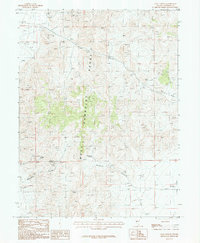
1987 Map of Coal Canyon
USGS Topo · Published 1988About this map
Mining activity and rugged topography define this section of the Humboldt Range in Pershing County, Nevada. The map documents an extensive history of resource extraction, illustrated by numerous Prospects and specific workings like the Prospect Mine Shaft and several Adits. The presence of a Gypsum deposit further highlights the mineral variety found within the ridges. Water sources are scarce in this arid environment, making landmarks such as Muttlebury Spring and Muttlebury Well critical points for early explorers and prospectors. The landscape is carved by significant drainages, including Coal Canyon and Muttlebury Canyon, which channel toward Packard Wash. This provisional survey reflects the area's transition between the West Humboldt Range and the high desert basins, providing a detailed record of the mining sites that once drew people to these remote canyons.
Find a feature on this map
16 named features on this map. Tap any name to fly to it.
Don’t see what you’re looking for? This feature index may not catch every label — zoom into the map to look around manually.
Map Details
Editions of this 1987 Coal Canyon Map
This is the sole edition of this map. No revisions or reprints were ever made.
Other maps of this area

1931 · Lovelock
USGS Topo · 1:250,000

1935 · Lovelock
USGS Topo · 1:250,000

1954 · Unionville
USGS Topo · 1:62,500

1954 · Buffalo Mtn
USGS Topo · 1:62,500

1955 · Lovelock
USGS Topo · 1:250,000

1956 · Oreana
USGS Topo · 1:62,500

1956 · Lovelock
USGS Topo · 1:62,500

1959 · Lovelock
USGS Topo · 1:250,000

1984 · Lovelock
USGS Topo · 1:100,000
1987 · Buffalo Mountain
USGS Topo · 1:24,000