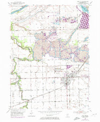
1953 Map of Coal City
USGS Topo · Published 1974About this map
The industrial legacy of Goose Lake and the surrounding prairies is defined here by an extensive network of Strip Mine operations and numerous Mine Dumps that dominate the landscape between the Illinois River and Coal City. This 1953 survey, updated with 1973 revisions, reveals a dense concentration of mining infrastructure and rail lines, including the Elgin Joliet and Eastern and the Atchison Topeka and Santa Fe RR, which served the extraction industry.
Find a feature on this map
36 named features on this map. Tap any name to fly to it.
Don’t see what you’re looking for? This feature index may not catch every label — zoom into the map to look around manually.
Map Details
Editions of this 1953 Coal City Map
5 editions found

Other maps of this area

1892 · Morris
USGS Topo · 1:62,500

1892 · Wilmington
USGS Topo · 1:62,500

1918 · Wilmington
USGS Topo · 1:62,500

1918 · Morris
USGS Topo · 1:62,500

1923 · Herscher
USGS Topo · 1:62,500

1925 · Herscher
USGS Topo · 1:62,500

1948 · Dwight
USGS Topo · 1:62,500

1950 · Dwight
USGS Topo · 1:62,500

1953 · Morris
USGS Topo · 1:24,000

1953 · Lisbon
USGS Topo · 1:24,000