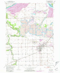
1953 Map of Coal City
USGS Topo · Published 1981About this map
Coal City and its neighboring settlements define the landscape of Grundy County in this mid-century survey, which reveals an economy deeply tied to the earth. The area is characterized by an extensive network of strip mines, with numerous mine dumps scattered near Carbon Hill and Eileen. To the north, the protected grounds of Goose Lake Prairie State Park contrast with the industrial activity, preserving a segment of the original tallgrass prairie. The confluence of the Illinois River and Kankakee River at the northeast corner provides a natural boundary, while the Mazon River meanders through the western portion of the map. Local history is documented through landmarks like Holderman Cem, Pine Bluff Sch, and Dell Abbey, alongside the heavy presence of the Elgin Joliet and Eastern and other major rail lines that once moved coal and commerce through the region.
Find a feature on this map
31 named features on this map. Tap any name to fly to it.
Don’t see what you’re looking for? This feature index may not catch every label — zoom into the map to look around manually.
Map Details
Editions of this 1953 Coal City Map
5 editions found

Other maps of this area

1892 · Morris
USGS Topo · 1:62,500

1892 · Wilmington
USGS Topo · 1:62,500

1918 · Wilmington
USGS Topo · 1:62,500

1918 · Morris
USGS Topo · 1:62,500

1923 · Herscher
USGS Topo · 1:62,500

1925 · Herscher
USGS Topo · 1:62,500

1948 · Dwight
USGS Topo · 1:62,500

1950 · Dwight
USGS Topo · 1:62,500

1953 · Morris
USGS Topo · 1:24,000

1953 · Lisbon
USGS Topo · 1:24,000