
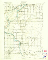
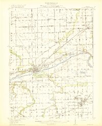
1918 Map of Wilmington
USGS Topo · Published 1918About this map
The Des Plaines River and Kankakee River converge in this Illinois landscape, creating a hub of early industrial and transit routes during the First World War. The legacy of the Illinois and Michigan Canal is clearly visible alongside the modern rail corridors of the Chicago and Alton and the Atchison Topeka and Santa Fe. The map documents a dense network of rural schoolhouses, including the Red Brick School and the Schweizer School, which served the farming communities surrounding Wilmington and Braidwood. Numerous islands such as Mulberry Island and Treat Island dot the rivers, while topographic features like Kankakee Bluffs and Providence Ridge define the local relief. The settlement of Channahon sits at a critical junction of waterways and rail, reflecting an era when small-town depots and local schools were the anchors of the Will County countryside.
Find a feature on this map
96 named features on this map. Tap any name to fly to it.
Don’t see what you’re looking for? This feature index may not catch every label — zoom into the map to look around manually.
Map Details
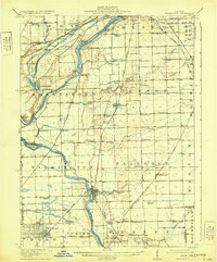
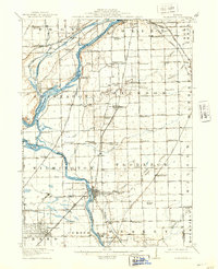
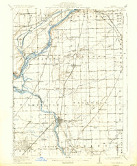
Editions of this 1918 Wilmington Map
5 editions found
Other maps of this area

1890 · Des Plaines
USGS Topo · 1:62,500

1892 · Morris
USGS Topo · 1:62,500

1892 · Joliet
USGS Topo · 1:62,500

1892 · Wilmington
USGS Topo · 1:62,500

1894 · Des Plaines
USGS Topo · 1:62,500

1900 · Des Plaines
USGS Topo · 1:62,500

1901 · Des Plaines
USGS Topo · 1:62,500
1918 · Morris
USGS Topo · 1:62,500
1922 · Kankakee
USGS Topo · 1:62,500

1923 · Joliet
USGS Topo · 1:62,500