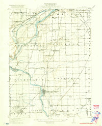
1918 Map of Wilmington
USGS Topo · Published 1918About this map
The Kankakee River and Des Plaines River converge in this territory, creating a landscape defined by waterway commerce and early twentieth-century rail expansion. The Michigan and Ottawa Canal and its DuPage Feeder parallel the rivers, signaling the era's reliance on canal transport alongside newer rail lines like the Chicago and Alton and the Wabash. Industrial and agricultural footprints are visible in the layout of Wilmington and the grid of Braidwood, while the countryside is densely dotted with neighborhood landmarks such as the Red Brick School and Keeversville School.
Find a feature on this map
93 named features on this map. Tap any name to fly to it.
Don’t see what you’re looking for? This feature index may not catch every label — zoom into the map to look around manually.
Map Details
Editions of this 1918 Wilmington Map
5 editions found
Other maps of this area

1890 · Des Plaines
USGS Topo · 1:62,500

1892 · Morris
USGS Topo · 1:62,500

1892 · Joliet
USGS Topo · 1:62,500

1892 · Wilmington
USGS Topo · 1:62,500

1894 · Des Plaines
USGS Topo · 1:62,500

1900 · Des Plaines
USGS Topo · 1:62,500

1901 · Des Plaines
USGS Topo · 1:62,500

1918 · Wilmington
USGS Topo · 1:62,500

1918 · Morris
USGS Topo · 1:62,500

1922 · Kankakee
USGS Topo · 1:62,500