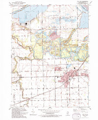
1993 Map of Coal City
USGS Topo · Published 1994About this map
Coal City and its neighboring clusters of Carbon Hill, Harrisonville, and Diamond anchor the southeastern portion of this landscape, reflecting a dense settlement pattern shaped by the region's industrial foundations. The Mazon River meanders northward toward the Illinois River, cutting through a terrain marked by extensive surface alterations and water-filled pits that hint at the area's coal-producing heritage. Large-scale conservation and water management dominate the northern half, where the Goose Lake Prairie State Park preserves a rare fragment of original tallgrass prairie adjacent to the massive Heidecke Lake. Local history is preserved in landmarks like the Holderman Cem and Faith Ch, while the transition from heavy industry to recreation is evident in the presence of the Heidecke State Fish And Wildlife Area and scattered mines.
Find a feature on this map
43 named features on this map. Tap any name to fly to it.
Don’t see what you’re looking for? This feature index may not catch every label — zoom into the map to look around manually.
Map Details
Editions of this 1993 Coal City Map
This is the sole edition of this map. No revisions or reprints were ever made.
Other maps of this area

1892 · Morris
USGS Topo · 1:62,500

1892 · Wilmington
USGS Topo · 1:62,500

1918 · Wilmington
USGS Topo · 1:62,500

1918 · Morris
USGS Topo · 1:62,500

1923 · Herscher
USGS Topo · 1:62,500

1925 · Herscher
USGS Topo · 1:62,500

1948 · Dwight
USGS Topo · 1:62,500

1950 · Dwight
USGS Topo · 1:62,500

1953 · Morris
USGS Topo · 1:24,000

1953 · Lisbon
USGS Topo · 1:24,000