
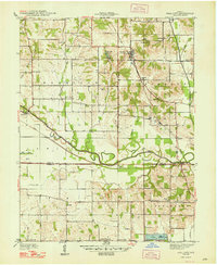
1948 Map of Coal City
USGS Topo · Published 1948About this map
Coal City and the surrounding borderlands of Owen, Clay, and Greene Counties are defined by the legacy of early Indiana transportation and industry. The most striking historical feature is the Wabash and Erie Canal (Abandoned), which parallels the winding course of the Eel River through the center of the sheet. By the time of this survey, the canal had long since been superseded by the New York Central railroad, which served local settlements like Daggett and Hubbell. The landscape is dotted with several coal mines, reflecting the region's extraction-based economy. For genealogists, the map provides precise locations for family-named landmarks including Sink Cem, Neihart Cem, and Duncan Cem, alongside rural institutions such as College Hill Sch and Bethsaida Ch.
Find a feature on this map
49 named features on this map. Tap any name to fly to it.
Don’t see what you’re looking for? This feature index may not catch every label — zoom into the map to look around manually.
Map Details
Editions of this 1948 Coal City Map
2 editions found
Other maps of this area

1908 · Clay City
USGS Topo · 1:48,000

1908 · Bloomfield
USGS Topo · 1:62,500

1910 · Clay City
USGS Topo · 1:62,500

1938 · Coal City
USGS Topo · 1:24,000

1938 · Switz City
USGS Topo · 1:24,000

1940 · Linton
USGS Topo · 1:24,000

1940 · Jasonville
USGS Topo · 1:24,000

1947 · Switz City
USGS Topo · 1:24,000

1947 · Linton
USGS Topo · 1:24,000

1950 · Arney
USGS Topo · 1:24,000