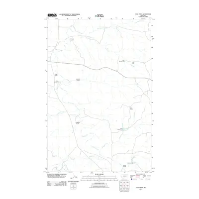
2011 Map of Coal Creek
USGS Topo · Published 2011About this map
Coal Creek and the intricate drainage network of northern McCone County define this prairie landscape, where seasonal waterways have carved out distinct topographical features like Hook Rock and the White Buttes. The distribution of water is a central theme of this 2011 map, evidenced by man-made infrastructure such as Jeffrey Number 1 Dam, Frady Number 1 Dam, and Stevens Coulee Number 1 Dam. These small-scale impoundments on the Little Dry Creek and Gibbs Creek systems highlight the importance of water management for local land use. Numerous coulees, including Wilkinson Coulee, Calamity Coulee, and Norwegian Coulee, mark the terrain, revealing the natural erosion patterns across this part of the Montana plains. Rural access is maintained via Van Norman Rd and Vail Rd, connecting these remote landmarks to the wider region.
Find a feature on this map
21 named features on this map. Tap any name to fly to it.
Don’t see what you’re looking for? This feature index may not catch every label — zoom into the map to look around manually.
Map Details
Editions of this 2011 Coal Creek Map
This is the sole edition of this map. No revisions or reprints were ever made.
Other maps of this area

1954 · Jordan
USGS Topo · 1:250,000

1956 · Jordan
USGS Topo · 1:250,000

1958 · Jordan
USGS Topo · 1:250,000

1964 · Jordan
USGS Topo · 1:250,000

1965 · Whiteside Ranch
USGS Topo · 1:24,000

1965 · Hedstrom Lake NW
USGS Topo · 1:24,000

1965 · Hafla School
USGS Topo · 1:24,000

1967 · Hagen Gap
USGS Topo · 1:24,000
1967 · Maxwell Coulee
USGS Topo · 1:24,000

1967 · Coal Creek
USGS Topo · 1:24,000