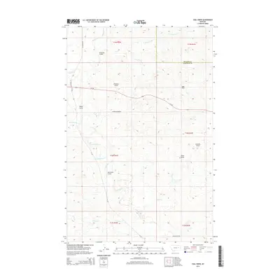
2014 Map of Coal Creek
USGS Topo · Published 2014About this map
Coal Creek and its many tributaries, including N Prong Coal Cr, carve through this sparsely populated stretch of the eastern Montana plains. The landscape is defined by its complex drainage network, where seasonal waterways like Little Dry Creek and Big Wild Horse Creek have weathered the terrain into numerous coulees. Notable landmarks such as White Buttes and Hook Rock provide vertical relief against the surrounding basin. The survey also traces the early 21st-century path of MT-200 as it crosses the northern half of the quadrangle, passing near Wilkinson Coulee. This map captures a region primarily focused on water management and ranching navigation, evidenced by the intricate system of named coulees like Calamity Coulee and Norwegian Coulee that served as vital markers in the vast Big Dry drainage area.
Find a feature on this map
25 named features on this map. Tap any name to fly to it.
Don’t see what you’re looking for? This feature index may not catch every label — zoom into the map to look around manually.
Map Details
Editions of this 2014 Coal Creek Map
This is the sole edition of this map. No revisions or reprints were ever made.
Other maps of this area

1954 · Jordan
USGS Topo · 1:250,000

1956 · Jordan
USGS Topo · 1:250,000

1958 · Jordan
USGS Topo · 1:250,000

1964 · Jordan
USGS Topo · 1:250,000

1965 · Whiteside Ranch
USGS Topo · 1:24,000

1965 · Hedstrom Lake NW
USGS Topo · 1:24,000

1965 · Hafla School
USGS Topo · 1:24,000

1967 · Hagen Gap
USGS Topo · 1:24,000
1967 · Maxwell Coulee
USGS Topo · 1:24,000

1967 · Coal Creek
USGS Topo · 1:24,000