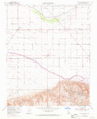
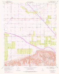
1955 Map of Coal Oil Canyon
USGS Topo · Published 1970About this map
Wheeler Ridge Oil Field dominates the southern landscape of this Kern County survey, where heavy industrial infrastructure meets the arid floor of the San Joaquin Valley. The map captures a pivotal moment of mid-century water engineering, showing the California Aqueduct (Under Construction) cutting northwest across the valley floor, alongside the projected Site for Wheeler Ridge Pumping Plant. To the north, the vast Kern Lake Bed suggests the historical hydrology of the region, now crisscrossed by the Copus Road and dotted with ranching and utility features like a Cotton Gin and several water tanks. Small pockets of local activity appear at the Lakeview Duck Club and the settlement of Lakeview, while the Fages-Zalvidea Trails Marker provides a rare nod to early California exploration routes crossing this rugged petroleum-rich terrain.
Find a feature on this map
27 named features on this map. Tap any name to fly to it.
Don’t see what you’re looking for? This feature index may not catch every label — zoom into the map to look around manually.
Map Details
Editions of this 1955 Coal Oil Canyon Map
5 editions found
Other maps of this area

1903 · Mt. Pinos
USGS Topo · 1:125,000

1903 · Tejon
USGS Topo · 1:125,000

1910 · Buena Vista Lake
USGS Topo · 1:125,000

1912 · Buena Vista Lake
USGS Topo · 1:125,000

1914 · Caliente
USGS Topo · 1:125,000

1930 · Weed Patch
USGS Topo · 1:31,680

1930 · Millux
USGS Topo · 1:31,680

1930 · Conner
USGS Topo · 1:31,680

1931 · West of Tejon Hills
USGS Topo · 1:31,680

1931 · Hayes Ranch
USGS Topo · 1:31,680