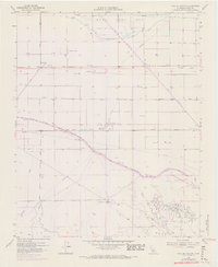
1955 Map of Coal Oil Canyon
USGS Topo · Published 1970About this map
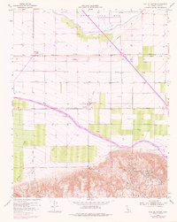
The dry Kern Lake Bed dominates the northern landscape of this Kern County region, revealing a terrain heavily modified for water management and resource extraction. Surrounded by an extensive system of Levees and a Ditch, the former lakebed sits north of the industrial corridor defined by the California Aqueduct. This survey captures the mid-century transition from traditional agriculture to intensive energy production, centered on the Wheeler Ridge Oil Field and its complex network of pipelines and storage facilities.
Find a feature on this map
28 named features on this map. Tap any name to fly to it.
Don’t see what you’re looking for? This feature index may not catch every label — zoom into the map to look around manually.
Map Details
Editions of this 1955 Coal Oil Canyon Map
5 editions found
Other maps of this area

1903 · Mt. Pinos
USGS Topo · 1:125,000

1903 · Tejon
USGS Topo · 1:125,000

1910 · Buena Vista Lake
USGS Topo · 1:125,000

1912 · Buena Vista Lake
USGS Topo · 1:125,000

1914 · Caliente
USGS Topo · 1:125,000

1930 · Weed Patch
USGS Topo · 1:31,680

1930 · Millux
USGS Topo · 1:31,680

1930 · Conner
USGS Topo · 1:31,680

1931 · West of Tejon Hills
USGS Topo · 1:31,680

1931 · Hayes Ranch
USGS Topo · 1:31,680