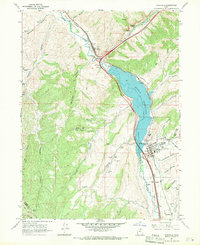
1967 Map of Coalville
USGS Topo · Published 1970About this map
The Weber River corridor serves as the primary artery of travel and settlement in this 1967 survey of Summit County. The landscape is dominated by the Echo Reservoir, a significant impoundment whose underwater contours were recorded by the U.S. Bureau of Reclamation. At the southern end of the reservoir, the town of Coalville functions as a hub of civic life, featuring the North Summit High School, a cemetery, and the Rodeo Grounds. This area reflects the mid-century transition of the region, where older irrigation works like the Big Robinson Ditch and Chalk Creek intersect with modern infrastructure.
Find a feature on this map
46 named features on this map. Tap any name to fly to it.
Don’t see what you’re looking for? This feature index may not catch every label — zoom into the map to look around manually.
Map Details
Editions of this 1967 Coalville Map
This is the sole edition of this map. No revisions or reprints were ever made.
Other maps of this area

1885 · Salt Lake
USGS Topo · 1:250,000

1900 · Coalville
USGS Topo · 1:125,000

1903 · Coalville
USGS Topo · 1:125,000

1925 · Ft. Douglas
USGS Topo · 1:125,000

1928 · Ft. Douglas
USGS Topo · 1:125,000

1954 · Salt Lake City
USGS Topo · 1:250,000

1954 · Ogden
USGS Topo · 1:250,000

1958 · Ogden
USGS Topo · 1:250,000

1958 · Salt Lake City
USGS Topo · 1:250,000

1960 · Ogden
USGS Topo · 1:250,000