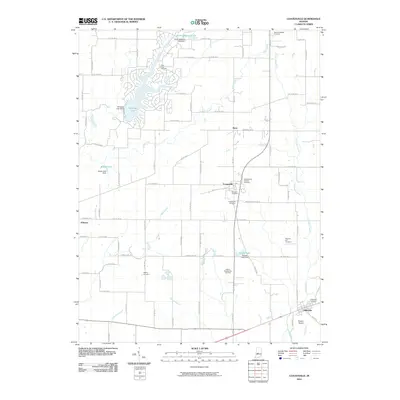
2010 Map of Coatesville
USGS Topo · Published 2010About this map
Coatesville serves as the central hub of this Indiana landscape, where the local road network converges near the Moravian Cemetery and West Branch Friends Cemetery. The geography is defined by a series of small, dammed reservoirs, including the expansive residential development around Heritage Lake and the smaller Sunset Lake to the south. These man-made features sit alongside natural drainage systems like Miller Creek and Crittenden Creek, which snake through the agricultural parcels of Hendricks and Putnam Counties. Genealogists will find a high density of burial sites across the township, from the Stilesville Cemetery in the southeast to the New Winchester Cemetery in the north. The presence of Vaughn Airport near Stilesville and the established grid of county roads, such as E Range Line Rd, reflect a region balanced between its rural farming roots and mid-century recreational growth.
Find a feature on this map
61 named features on this map. Tap any name to fly to it.
Don’t see what you’re looking for? This feature index may not catch every label — zoom into the map to look around manually.
Map Details
Editions of this 2010 Coatesville Map
This is the sole edition of this map. No revisions or reprints were ever made.
Other maps of this area

1953 · Clayton
USGS Topo · 1:24,000

1953 · Danville
USGS Topo · 1:24,000

1953 · Indianapolis
USGS Topo · 1:250,000

1955 · Hall
USGS Topo · 1:24,000

1956 · Indianapolis
USGS Topo · 1:250,000

1956 · Cloverdale
USGS Topo · 1:24,000

1956 · Eminence
USGS Topo · 1:24,000

1957 · Indianapolis
USGS Topo · 1:250,000

1958 · Roachdale
USGS Topo · 1:24,000

1958 · Coatesville
USGS Topo · 1:24,000