
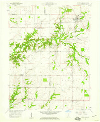
1958 Map of Coatesville
USGS Topo · Published 1959About this map
Coatesville and its surroundings in western Hendricks and Putnam counties are defined by the meeting of productive agricultural land and critical mid-century transportation corridors. The map documents a landscape where the Pennsylvania and New York Central railroads cut through the terrain, supporting local commerce through infrastructure like the Grain Storage Bins and a Pumping Station near Reno. Small community hubs are centered around landmarks such as Bethel Ch and the Canaan Ch Cem, while the natural drainage of Mill Creek and its many tributaries, including Sallust Branch, dictate the township boundaries of Marion, Floyd, and Franklin. The southeastern corner shows the early development of Stilesville near the H S Memorial, marking the transition into the Jefferson township area.
Find a feature on this map
31 named features on this map. Tap any name to fly to it.
Don’t see what you’re looking for? This feature index may not catch every label — zoom into the map to look around manually.
Map Details
Editions of this 1958 Coatesville Map
This is the sole edition of this map. No revisions or reprints were ever made.
Other maps of this area

1953 · Clayton
USGS Topo · 1:24,000

1953 · Danville
USGS Topo · 1:24,000

1953 · Indianapolis
USGS Topo · 1:250,000

1955 · Hall
USGS Topo · 1:24,000

1956 · Indianapolis
USGS Topo · 1:250,000

1956 · Cloverdale
USGS Topo · 1:24,000

1956 · Eminence
USGS Topo · 1:24,000

1957 · Indianapolis
USGS Topo · 1:250,000

1958 · Roachdale
USGS Topo · 1:24,000
1958 · North Salem
USGS Topo · 1:24,000