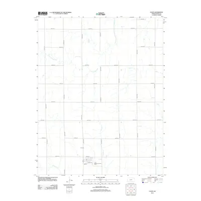
2012 Map of Coats
USGS Topo · Published 2012About this map
The town of Coats sits as the central hub of this Kansas landscape, defined by a rigid grid of rural roads and the winding paths of several regional waterways. Family historians and local researchers can trace the vicinity's geography through the drainage of the S Fork Ninnescah River and several branches of Elm Creek, including the E Br S Elm Cr and W Br S Elm Cr. These streams carve through the prairie, providing a natural contrast to the straight-line precision of avenues and streets like Santa Fe Ave and Main St.
Find a feature on this map
26 named features on this map. Tap any name to fly to it.
Don’t see what you’re looking for? This feature index may not catch every label — zoom into the map to look around manually.
Map Details
Editions of this 2012 Coats Map
This is the sole edition of this map. No revisions or reprints were ever made.
Other maps of this area

1891 · Medicine Lodge
USGS Topo · 1:125,000

1892 · Pratt
USGS Topo · 1:125,000

1893 · Medicine Lodge
USGS Topo · 1:125,000

1894 · Pratt
USGS Topo · 1:125,000

1955 · Pratt
USGS Topo · 1:250,000

1959 · Pratt
USGS Topo · 1:250,000

1968 · Pratt SW
USGS Topo · 1:24,000
1968 · Sun City
USGS Topo · 1:24,000

1968 · Pratt
USGS Topo · 1:24,000

1968 · Cullison
USGS Topo · 1:24,000