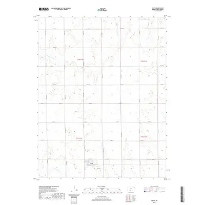
2018 Map of Coats
USGS Topo · Published 2018About this map
Coats sits as the central settlement of this Pratt County landscape, arranged along a grid including Main St and Santa Fe Ave. The surrounding rural expanse is defined by the headwaters and tributaries of several prairie streams, most notably the S Fork Ninnescah River which cuts through the northern sections. To the north of the town center, the Coats Cem serves as a significant landmark for those tracing local family lineages. The drainage patterns are intricate here, with the E Br S Elm Cr, W Br S Elm Cr, and N Elm Cr all converging south of the townsite, illustrating the hydrologic network that supported agricultural development in this part of Kansas.
Find a feature on this map
35 named features on this map. Tap any name to fly to it.
Don’t see what you’re looking for? This feature index may not catch every label — zoom into the map to look around manually.
Map Details
Editions of this 2018 Coats Map
This is the sole edition of this map. No revisions or reprints were ever made.
Other maps of this area

1891 · Medicine Lodge
USGS Topo · 1:125,000

1892 · Pratt
USGS Topo · 1:125,000

1893 · Medicine Lodge
USGS Topo · 1:125,000

1894 · Pratt
USGS Topo · 1:125,000

1955 · Pratt
USGS Topo · 1:250,000

1959 · Pratt
USGS Topo · 1:250,000

1968 · Pratt SW
USGS Topo · 1:24,000
1968 · Sun City
USGS Topo · 1:24,000

1968 · Pratt
USGS Topo · 1:24,000

1968 · Cullison
USGS Topo · 1:24,000