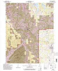
1996 Map of Cobden
USGS Topo · Published 1998About this map
Bald Knob Wilderness and the surrounding reaches of the Shawnee National Forest define this 1990s landscape in southern Illinois. The rugged terrain, anchored by the high point of Bald Knob, transitions from protected woods into the fruit-growing hills near Cobden and Alto Pass. The Illinois Central Gulf railroad serves as a primary transit corridor through the valley, connecting the small communities of Mountain Glen and Pomona. This survey, updated with 1996 data, preserves the locations of numerous historic rural landmarks, including Union Springs Ch and several family burial grounds like Hagler Cem and Collins Cem. The southern portion of the map is dominated by the Trail of Tears State Forest, providing a detailed look at the public lands and forest management boundaries established by the turn of the millennium.
Find a feature on this map
34 named features on this map. Tap any name to fly to it.
Don’t see what you’re looking for? This feature index may not catch every label — zoom into the map to look around manually.
Map Details
Editions of this 1996 Cobden Map
This is the sole edition of this map. No revisions or reprints were ever made.
Other maps of this area

1920 · Jonesboro
USGS Topo · 1:62,500

1920 · Dongola
USGS Topo · 1:62,500

1922 · Carbondale
USGS Topo · 1:62,500

1923 · Dongola
USGS Topo · 1:62,500

1923 · Jonesboro
USGS Topo · 1:62,500

1924 · Alto Pass
USGS Topo · 1:62,500

1941 · Carbondale
USGS Topo · 1:62,500

1947 · Jonesboro
USGS Topo · 1:62,500

1947 · Alto Pass
USGS Topo · 1:62,500

1947 · Gorham
USGS Topo · 1:24,000