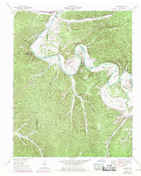
1952 Map of Coble
USGS Topo · Published 1970About this map
The Duck River carves a deep, winding path through this corner of Middle Tennessee, defining the landscape with dramatic loops like Brown Bend, Burchard Town Bend, and Wright Bend. This era of development is marked by the presence of an Airway beacon and the Tennessee Center for Youthful Offenders listed as under construction near Burchard Town Bend. Local life centers around the small settlements of Only and Coble, while a network of family cemeteries—including King Cem, Grandmother Ford Cem, and Walker Cem—is scattered among the many hollows like Schoolhouse Hollow and Ammons Hollow. The map records a river-dependent geography where historic crossing points like Grandmother Ford and Alexander Ford remained significant landmarks alongside newer features like the Beaverdam Bridge.
Find a feature on this map
89 named features on this map. Tap any name to fly to it.
Don’t see what you’re looking for? This feature index may not catch every label — zoom into the map to look around manually.
Map Details
Editions of this 1952 Coble Map
2 editions found
Other maps of this area

1936 · Pleasantville
USGS Topo · 1:24,000

1936 · Hurricane Mills
USGS Topo · 1:24,000

1936 · Coble
USGS Topo · 1:24,000

1936 · Beaverdam Springs
USGS Topo · 1:24,000

1936 · Whitfield
USGS Topo · 1:24,000

1936 · Bucksnort
USGS Topo · 1:24,000

1936 · Chestnut Grove
USGS Topo · 1:24,000

1936 · Spot
USGS Topo · 1:24,000

1936 · Lobelville
USGS Topo · 1:24,000
1950 · Chestnut Grove
USGS Topo · 1:24,000