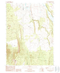
1990 Map of Coble Mountain
USGS Topo · Published 1990About this map
Lassen National Forest encompasses much of this northeastern California landscape, where the volcanic character of the terrain is evident in features like the Cinder Cone and Cinder Pit. The map captures a transition from the volcanic heights of Coble Mountain down into the drainage of the Pit River, which carves along the eastern boundary. This area, straddling the Shasta Co Lassen Co line, reflects a sparsely populated ranching and timber environment of the late 20th century. Local landmarks such as Burton Ranch and Peterson Ranch indicate a quiet pattern of land use, while geologic features like Big Cave and Popcorn Cave offer a look into the subterranean complexities of the volcanic plateau. Seasonal hydrology is marked by several water sources, including Beaver Creek and Willow Spring, which supported the livestock and local families of the region.
Find a feature on this map
17 named features on this map. Tap any name to fly to it.
Don’t see what you’re looking for? This feature index may not catch every label — zoom into the map to look around manually.
Map Details
Editions of this 1990 Coble Mountain Map
This is the sole edition of this map. No revisions or reprints were ever made.
Other maps of this area

1886 · Lassen Peak
USGS Topo · 1:250,000

1886 · Modoc Lava Bed
USGS Topo · 1:250,000

1892 · Modoc Lava-Bed
USGS Topo · 1:250,000

1892 · Lassen Peak
USGS Topo · 1:250,000

1894 · Lassen Peak
USGS Topo · 1:250,000

1939 · Halls Flat
USGS Topo · 1:125,000

1954 · Alturas
USGS Topo · 1:250,000

1955 · Westwood
USGS Topo · 1:250,000

1957 · Little Valley
USGS Topo · 1:62,500

1957 · Jellico
USGS Topo · 1:62,500