
1964 Map of Coburg
USGS Topo · Published 1967About this map
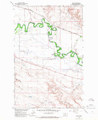
Coburg serves as the focal point of this northern Montana landscape, situated along the Great Northern railroad line during the mid-1960s. The geography is dominated by the winding path of the Milk River, which meanders through the heart of the area, accompanied by a network of waterways including Milk Creek, White Bear Creek, and Peoples Creek. This survey captures the vital irrigation infrastructure of the era, most notably the Main Canal, which parallels the river valley to support the region's agricultural interests.
Find a feature on this map
11 named features on this map. Tap any name to fly to it.
Don’t see what you’re looking for? This feature index may not catch every label — zoom into the map to look around manually.
Map Details
Editions of this 1964 Coburg Map
This is the sole edition of this map. No revisions or reprints were ever made.
Other maps of this area

1903 · Wayne Creek
USGS Topo · 1:62,500

1905 · Wayne Creek
USGS Topo · 1:62,500

1913 · Cherry Ridge
USGS Topo · 1:125,000

1920 · Avery
USGS Topo · 1:125,000

1953 · Havre
USGS Topo · 1:250,000

1957 · Havre
USGS Topo · 1:250,000

1958 · Havre
USGS Topo · 1:250,000

1964 · Wayne Creek SE
USGS Topo · 1:24,000

1964 · Coburg SE
USGS Topo · 1:24,000
1964 · Savoy
USGS Topo · 1:24,000