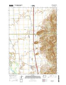
2014 Map of Coburg
USGS Topo · Published 2014About this map
Coburg serves as the primary hub in this Willamette Valley landscape, where the flat agricultural plains of the valley floor meet the rising elevations of the Coburg Hills. The map details a complex drainage system essential for the region's fertile lands, featuring Muddy Cr, Dry Muddy Cr, and several sloughs including Mill Slough and Cartwright Slough. Local infrastructure is marked by several small aviation fields, including Greer Airport, West Point Airport, and Briggs Airport, reflecting a mix of private and agricultural utility. To the east, the terrain shifts abruptly at prominent landmarks such as Rock Hill, Centennial Butte, and Lenon Hill. These elevations define the boundary between the cultivated basin and the forested uplands, providing a clear view of how the Willamette River floodplain has shaped local settlement patterns and road networks like N Coburg Rd.
Find a feature on this map
60 named features on this map. Tap any name to fly to it.
Don’t see what you’re looking for? This feature index may not catch every label — zoom into the map to look around manually.
Map Details
Editions of this 2014 Coburg Map
This is the sole edition of this map. No revisions or reprints were ever made.
Other maps of this area

1909 · Harrisburg
USGS Topo · 1:31,680

1909 · Rowland
USGS Topo · 1:31,680

1910 · Eugene
USGS Topo · 1:62,500

1912 · Halsey
USGS Topo · 1:62,500

1921 · Brownsville
USGS Topo · 1:62,500

1940 · Eugene
USGS Topo · 1:62,500

1941 · Halsey
USGS Topo · 1:62,500

1946 · Eugene
USGS Topo · 1:62,500

1949 · Eugene
USGS Topo · 1:62,500

1950 · Marcola
USGS Topo · 1:62,500