
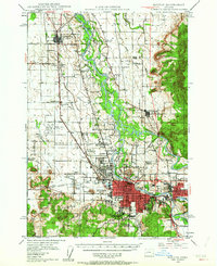
1946 Map of Eugene
USGS Topo · Published 1957About this map
The Willamette River valley serves as the central artery for this 1946 culture revision, where the river braids around extensive landforms like Goodpasture Island and Marshall Island. The urban centers of Eugene and Springfield are shown in significant detail, including local landmarks like the Country Club Golf Course and early broadcasting sites for Radio Sta KUGN and Radio Sta KORE. This era was defined by a transition in transportation, as the Oregon Electric Railroad and the Southern Pacific Railroad shared the landscape with the burgeoning Mahlon Sweet Airport. Local life is anchored by a dense network of rural schoolhouses and cemeteries, including the Colin Kelly Sch and the I O O F Cemetery, while smaller settlements such as Stumptown and Junction City mark the primary rail and road corridors through the valley.
Find a feature on this map
76 named features on this map. Tap any name to fly to it.
Don’t see what you’re looking for? This feature index may not catch every label — zoom into the map to look around manually.
Map Details
Editions of this 1946 Eugene Map
2 editions found
Other maps of this area

1909 · Harrisburg
USGS Topo · 1:31,680

1909 · Rowland
USGS Topo · 1:31,680

1909 · Elmira
USGS Topo · 1:62,500

1910 · Eugene
USGS Topo · 1:62,500

1911 · Monroe
USGS Topo · 1:31,680

1912 · Halsey
USGS Topo · 1:62,500

1921 · Brownsville
USGS Topo · 1:62,500

1921 · Cottage Grove
USGS Topo · 1:62,500

1922 · Monroe
USGS Topo · 1:62,500

1922 · Elmira
USGS Topo · 1:62,500