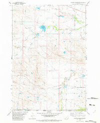
1982 Map of Cochran Reservoir
USGS Topo · Published 1982About this map
Cochran Reservoir sits at the heart of this high plains landscape, where the drainage systems of the North Fork Willow Creek, Middle Fork Willow Creek, and South Fork Willow Creek converge. The topography is defined by significant draws and ridges, most notably Zimmerman Draw and Torgerson Draw, which illustrate the erosion patterns characteristic of the Montana and Wyoming borderlands. The map traces the boundary between Carter County and Crook County, as well as the Montana and Wyoming state line, marking a sparsely settled ranching or resource area. Infrastructure is limited to essential corridors like the Pipeline and the prominent Ridge Road, which follows the high ground above Thompson Creek and Nelson Washout. This survey provides a precise look at the water management and transport routes across this remote interstate frontier in the early 1980s.
Find a feature on this map
15 named features on this map. Tap any name to fly to it.
Don’t see what you’re looking for? This feature index may not catch every label — zoom into the map to look around manually.
Map Details
Editions of this 1982 Cochran Reservoir Map
This is the sole edition of this map. No revisions or reprints were ever made.
Other maps of this area

1905 · Devils Tower
USGS Topo · 1:125,000

1954 · Ekalaka
USGS Topo · 1:250,000

1954 · Gillette
USGS Topo · 1:250,000

1955 · Gillette
USGS Topo · 1:250,000

1956 · Ekalaka
USGS Topo · 1:250,000

1957 · Seely
USGS Topo · 1:62,500

1957 · Cedar Ridge
USGS Topo · 1:62,500

1958 · Gillette
USGS Topo · 1:250,000

1958 · Ekalaka
USGS Topo · 1:250,000

1962 · Gillette
USGS Topo · 1:250,000