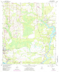
1956 Map of Coden
USGS Topo · Published 1985About this map
The coastal landscapes of the Gulf of Mexico meet the intricate water networks of southern Mobile County in this mid-century survey. The settlement of Bayou La Batre anchors the southwestern corner, showing a detailed grid of streets and structures near the harbor before significant modernization. To the east, Mon Louis Island is defined by the Fowl River and its various branches, including the East Fowl River and The Narrows. This document preserves the locations of local landmarks such as Bellingrath Gardens and the Roy E Ray Airport, alongside smaller community centers like Delchamps and Laurendine. The mapping of an Old Railroad Grade and numerous bayous, including Jonas Bayou and Bayou Sullivan, provides a clear view of the historical drainage and transportation patterns that shaped the region's development.
Find a feature on this map
53 named features on this map. Tap any name to fly to it.
Don’t see what you’re looking for? This feature index may not catch every label — zoom into the map to look around manually.
Map Details
Editions of this 1956 Coden Map
3 editions found
Other maps of this area

1921 · Grand Bay
USGS Topo · 1:62,500

1921 · Delchamps
USGS Topo · 1:62,500

1922 · Mobile
USGS Topo · 1:62,500

1940 · Hollingers Island
USGS Topo · 1:31,680

1940 · Mobile
USGS Topo · 1:62,500

1941 · Cedar Point
USGS Topo · 1:62,500

1941 · Hurley
USGS Topo · 1:62,500

1942 · Theodore
USGS Topo · 1:31,680

1943 · Cedar Point
USGS Topo · 1:62,500

1943 · Theodore
USGS Topo · 1:31,680