
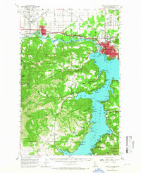
1957 Map of Coeur D'Alene
USGS Topo · Published 1959About this map
Coeur d'Alene Lake and the Spokane River serve as the focal points for this mid-century survey, illustrating a landscape defined by timber, water, and expanding timber-town infrastructure. The northern portion of the map showcases the agricultural transition of Rathdrum Prairie, while the shoreline is dotted with industrial and civic markers such as the mills at Gibbs and Blackwell, and the Junior College in the city center. A dense network of railroads, including the Great Northern and the Northern Pacific, converges at Grand Junction, highlighting the region's importance as a transportation hub for the Inland Northwest.
Find a feature on this map
84 named features on this map. Tap any name to fly to it.
Don’t see what you’re looking for? This feature index may not catch every label — zoom into the map to look around manually.
Map Details
Editions of this 1957 Coeur D'Alene Map
2 editions found
Other maps of this area

1901 · Spokane
USGS Topo · 1:125,000

1903 · Oakesdale
USGS Topo · 1:125,000

1903 · Rathdrum
USGS Topo · 1:125,000

1905 · Oakesdale
USGS Topo · 1:125,000

1943 · Mt Spokane
USGS Topo · 1:62,500

1949 · Greenacres
USGS Topo · 1:62,500

1950 · Mt Spokane
USGS Topo · 1:62,500

1951 · Greenacres
USGS Topo · 1:62,500

1954 · Fairfield
USGS Topo · 1:62,500

1955 · Spokane
USGS Topo · 1:250,000