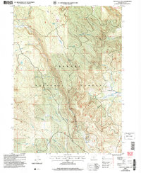
2004 Map of Coffeepot Creek
USGS Topo · Published 2007About this map
Fremont National Forest dominates this Lake County landscape, a complex drainage network at the start of the twenty-first century. The map centers on the high-elevation terrain where the South Fork Coffeepot Creek and North Fork Beaver Creek originate. Human presence is marked by a handful of established outposts and transit routes, most notably the Scissors Cabin and the historic Taylor Place (Site) in the southern reaches. Steep ridges and narrow drainages like Elder Creek and Augur Creek characterize the topography, which is largely navigated via specialized trails rather than paved roads. The Hanan Trail and Dead Horse Rim Trail provide a look at how this high-desert forest was managed and accessed, while local names like Corral Ring Creek and Little Coffeepot Spring hint at the area's legacy of stock grazing and water management.
Find a feature on this map
34 named features on this map. Tap any name to fly to it.
Don’t see what you’re looking for? This feature index may not catch every label — zoom into the map to look around manually.
Map Details
Editions of this 2004 Coffeepot Creek Map
This is the sole edition of this map. No revisions or reprints were ever made.
Other maps of this area

1955 · Klamath Falls
USGS Topo · 1:250,000

1958 · Klamath Falls
USGS Topo · 1:250,000

1960 · Fishhole Mtn
USGS Topo · 1:62,500

1964 · Coleman Point
USGS Topo · 1:24,000

1964 · Shoestring Butte
USGS Topo · 1:24,000

1966 · Morgan Butte
USGS Topo · 1:24,000

1966 · Slide Mtn
USGS Topo · 1:24,000

1966 · Harvey Creek
USGS Topo · 1:24,000

1966 · Coffeepot Creek
USGS Topo · 1:24,000

1966 · Paisley
USGS Topo · 1:24,000