
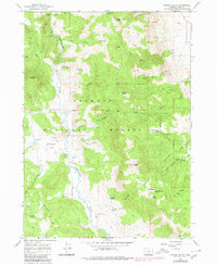
1966 Map of Morgan Butte
USGS Topo · Published 1968About this map
Morgan Butte serves as a prominent landmark in this high-altitude section of the Fremont National Forest, where a network of trails and jeep tracks connects various springs and meadows. The Chewaucan River winds through the western half of the terrain, flanked by significant elevations like McComb Butte and the Parker Hills. Local history interest centers on Whitehouse Place and the naming of features after early settlers, such as Brattain Butte, Ennis Butte, and Myers Meadow. The landscape is defined by its water sources, including Marsters Spring near a designated Campground, and Buckaroo Spring to the south. This 1960s survey documents the intricate drainage systems of the region, from Coffeepot Creek to the curiously named Schoolhouse Fork King Creek.
Find a feature on this map
45 named features on this map. Tap any name to fly to it.
Don’t see what you’re looking for? This feature index may not catch every label — zoom into the map to look around manually.
Map Details
Editions of this 1966 Morgan Butte Map
2 editions found
Other maps of this area

1955 · Klamath Falls
USGS Topo · 1:250,000

1958 · Klamath Falls
USGS Topo · 1:250,000

1964 · Coleman Point
USGS Topo · 1:24,000

1964 · Shoestring Butte
USGS Topo · 1:24,000

1964 · Clover Flat
USGS Topo · 1:24,000

1966 · Tucker Hill
USGS Topo · 1:24,000

1966 · Slide Mtn
USGS Topo · 1:24,000

1966 · Coglan Buttes
USGS Topo · 1:24,000

1966 · Coffeepot Creek
USGS Topo · 1:24,000

1966 · Paisley
USGS Topo · 1:24,000