
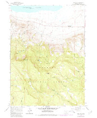
1966 Map of Slide Mtn
USGS Topo · Published 1968About this map
Summer Lake and its northern shoreline anchor this mid-1960s survey of the high desert and forested breaks in Lake County. The terrain rises sharply from the basin floor toward the timbered heights of the Fremont National Forest, where the Slide Mtn Lookout Tower stands as a prominent vantage point. This transition from alkaline lakebed to mountain pine is marked by numerous water sources, including the thermal waters at Summer Lake Hot Spring and several high-elevation bodies like Slide Lakes and Withers Lake.
Find a feature on this map
33 named features on this map. Tap any name to fly to it.
Don’t see what you’re looking for? This feature index may not catch every label — zoom into the map to look around manually.
Map Details
Editions of this 1966 Slide Mtn Map
2 editions found
Other maps of this area

1955 · Klamath Falls
USGS Topo · 1:250,000

1958 · Klamath Falls
USGS Topo · 1:250,000

1966 · Morgan Butte
USGS Topo · 1:24,000

1966 · Harvey Creek
USGS Topo · 1:24,000

1966 · Fremont Point
USGS Topo · 1:24,000

1966 · Coffeepot Creek
USGS Topo · 1:24,000

1966 · Paisley
USGS Topo · 1:24,000

1966 · Lee Thomas Crossing
USGS Topo · 1:24,000

1974 · Lake Abert
USGS Topo · 1:100,000
1986 · Loco Lake
USGS Topo · 1:24,000