
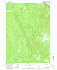
1966 Map of Coffeepot Creek
USGS Topo · Published 1968About this map
Fremont National Forest defines the character of this mid-1960s survey, illustrating a landscape of high-elevation drainages and seasonal water sources in Lake County. The map provides a detailed view of the complex hydrology feeding into Coffeepot Creek, with numerous named springs such as Coffeepot Spring, Puppydog Spring, and Cold Spring sustaining the local ecosystem. Evidence of human passage and land use is preserved in the location of Scissors Cabin and the route of the Hanan Trail, which traverses the northern reaches of the quadrangle. The terrain transitions from the steep drainages of Elder Creek and Witham Creek to the more open expanse of Coffeepot Flat. A small Gravel Pit near the center of the sheet indicates localized extraction efforts, likely for road maintenance within the forest's network of unimproved dirt tracks.
Find a feature on this map
29 named features on this map. Tap any name to fly to it.
Don’t see what you’re looking for? This feature index may not catch every label — zoom into the map to look around manually.
Map Details
Editions of this 1966 Coffeepot Creek Map
2 editions found
Other maps of this area

1955 · Klamath Falls
USGS Topo · 1:250,000

1958 · Klamath Falls
USGS Topo · 1:250,000

1960 · Fishhole Mtn
USGS Topo · 1:62,500

1964 · Coleman Point
USGS Topo · 1:24,000

1964 · Shoestring Butte
USGS Topo · 1:24,000

1966 · Morgan Butte
USGS Topo · 1:24,000

1966 · Slide Mtn
USGS Topo · 1:24,000

1966 · Harvey Creek
USGS Topo · 1:24,000

1966 · Paisley
USGS Topo · 1:24,000

1966 · Lee Thomas Crossing
USGS Topo · 1:24,000