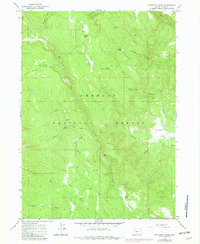
1966 Map of Coffeepot Creek
USGS Topo · Published 1982About this map
Fremont National Forest dominates this mid-1960s landscape in southern Oregon, where a complex network of high-elevation drainages feeds into the Chewaucan River basin. The terrain is defined by its numerous named springs and seasonal watercourses, including Coffeepot Spring and Puppydog Spring, which supported the livestock and timber activities of the era. The presence of Scissors Cabin and the Taylor Place (Site) provides a window into the historical human footprint within this protected forest land, suggesting isolated outposts for forest rangers or early ranchers.
Find a feature on this map
30 named features on this map. Tap any name to fly to it.
Don’t see what you’re looking for? This feature index may not catch every label — zoom into the map to look around manually.
Map Details
Editions of this 1966 Coffeepot Creek Map
2 editions found
Other maps of this area

1955 · Klamath Falls
USGS Topo · 1:250,000

1958 · Klamath Falls
USGS Topo · 1:250,000

1960 · Fishhole Mtn
USGS Topo · 1:62,500

1964 · Coleman Point
USGS Topo · 1:24,000

1964 · Shoestring Butte
USGS Topo · 1:24,000

1966 · Morgan Butte
USGS Topo · 1:24,000

1966 · Slide Mtn
USGS Topo · 1:24,000

1966 · Harvey Creek
USGS Topo · 1:24,000

1966 · Coffeepot Creek
USGS Topo · 1:24,000

1966 · Paisley
USGS Topo · 1:24,000