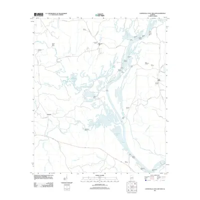
2011 Map of Coffeeville Lock And Dam
USGS Topo · Published 2011About this map
Tombigbee River dominates this landscape, serving as a primary corridor where the industrial extraction of the Barrytown Oil Field and Womack Hill Oil Field meets a historical river-landing economy. The area is characterized by numerous river features like Philans Shoal, Osage Bar, and the notable Secession Bluff near the southern edge. Small settlements such as Womack Hill and Flatwood are situated away from the floodplains, while specialized river infrastructure is evident at Gilbertown Dock and Bobbys Landing. Several family and community burial grounds, including Turner Cemetery and West Bend Cemetery, provide critical points of reference for genealogists. The complex hydrology of the region is further detailed by the broad reach of Coffeeville Lake and the branching network of Okatuppa Creek, highlighting the importance of water management and navigation in this part of Alabama.
Find a feature on this map
73 named features on this map. Tap any name to fly to it.
Don’t see what you’re looking for? This feature index may not catch every label — zoom into the map to look around manually.
Map Details
Editions of this 2011 Coffeeville Lock And Dam Map
This is the sole edition of this map. No revisions or reprints were ever made.
Other maps of this area

1953 · Hattiesburg
USGS Topo · 1:250,000

1958 · Hattiesburg
USGS Topo · 1:250,000

1971 · Coffeeville
USGS Topo · 1:24,000

1971 · Ararat
USGS Topo · 1:24,000

1971 · Bladon Springs
USGS Topo · 1:24,000

1971 · Coffeeville Lock And Dam
USGS Topo · 1:24,000

1972 · Tattlersville
USGS Topo · 1:24,000

1972 · Woods Bluff
USGS Topo · 1:24,000

1974 · Millry North
USGS Topo · 1:24,000

1974 · Silas
USGS Topo · 1:24,000