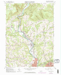
1965 Map of Cogan Station
USGS Topo · Published 1973About this map
Lycoming Creek carves a deep valley through the northern Appalachian highlands, guiding the Penn Central rail line and a string of mid-century communities. The map captures a detailed snapshot of settlement patterns in Lycoming County, ranging from the industrial outskirts of Williamsport to the rural ridges of Nail Factory Mtn and Scofield Mountain. The southern edge reveals the expansion of residential neighborhoods like Garden View and Vallamont Hills as they encroach upon the hills above the city. Higher up the valley, the transition from agricultural life to timbered heights is marked by historic sites such as the Blooming Grove Meetinghouse and St Michaels Ch. The landscape is dotted with local landmarks of the 1960s and 70s, including a Drive-in Theater near Woodland Park and the extensive grounds of Wildwood Cemetery.
Find a feature on this map
61 named features on this map. Tap any name to fly to it.
Don’t see what you’re looking for? This feature index may not catch every label — zoom into the map to look around manually.
Map Details
Editions of this 1965 Cogan Station Map
2 editions found
Other maps of this area

1921 · Williamsport
USGS Topo · 1:48,000

1921 · Trout Run
USGS Topo · 1:62,500

1923 · Trout Run
USGS Topo · 1:62,500

1923 · Williamsport
USGS Topo · 1:62,500

1924 · Milton
USGS Topo · 1:62,500

1930 · Warrensville
USGS Topo · 1:62,500

1934 · Warrensville
USGS Topo · 1:62,500

1944 · Trout Run
USGS Topo · 1:62,500

1944 · Williamsport
USGS Topo · 1:62,500

1953 · Warrensville
USGS Topo · 1:62,500
Featured Places
- Williamsport, PA
- Garden View, Old Lycoming Township
- Woodward Township, PA
- Cogan House Township, PA
- Old Lycoming Township, PA