
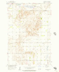
1957 Map of Cogswell
USGS Topo · Published 1958About this map
Cogswell and the smaller settlement of Nicholson anchor this mid-century portrait of Sargent County. The landscape is defined by the intersection of two major rail lines: the Minneapolis St Paul and Sault Ste Marie running east-west, and the Great Northern crossing the southern half of the quadrangle. These tracks reflect the rail-dependent economy of the North Dakota prairie, serving a grid of townships including Harlem and Brampton. To the south, the Wild Rice River meanders through the plains, while a large Slough dominates the western topography, illustrating the complex drainage of the Red River Valley. Several localized landmarks provide essential detail for genealogists, including Mt Calvary Cem, Old Sargent Cem, and the Nicholson Cem. The presence of a central Town Hall south of the main rail line highlights the civic organization of the rural community during this era.
Find a feature on this map
16 named features on this map. Tap any name to fly to it.
Don’t see what you’re looking for? This feature index may not catch every label — zoom into the map to look around manually.
Map Details
Editions of this 1957 Cogswell Map
This is the sole edition of this map. No revisions or reprints were ever made.
Other maps of this area

1952 · Crete
USGS Topo · 1:24,000

1953 · Kidder
USGS Topo · 1:24,000

1953 · Newark
USGS Topo · 1:24,000

1953 · Milbank
USGS Topo · 1:250,000

1953 · Fargo
USGS Topo · 1:250,000

1956 · Fargo
USGS Topo · 1:250,000
1956 · Straubville
USGS Topo · 1:24,000

1956 · Newark NW
USGS Topo · 1:24,000

1957 · Stirum
USGS Topo · 1:24,000

1958 · Milbank
USGS Topo · 1:250,000