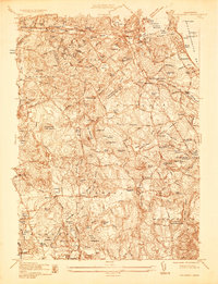
1936 Map of Cohasset
USGS Topo · Published 1936About this map
Cohasset and its surrounding South Shore towns are documented here in the mid-1930s, showing a coastal landscape defined by rocky ledges and tidal inlets. The New York New Haven and Hartford RR remains a central artery for the region, connecting maritime settlements like North Cohasset and Greenbush via stops such as Egypt Station and Beechwood Station. The terrain is marked by numerous family-named landmarks and historical sites, including the Old Oaken Bucket Homestead and the Union Mission Chapel near Satuit Meadow.
Find a feature on this map
91 named features on this map. Tap any name to fly to it.
Don’t see what you’re looking for? This feature index may not catch every label — zoom into the map to look around manually.
Map Details
Editions of this 1936 Cohasset Map
This is the sole edition of this map. No revisions or reprints were ever made.
Other maps of this area

1885 · Abington
USGS Topo · 1:62,500

1885 · Duxbury
USGS Topo · 1:62,500

1888 · Duxbury
USGS Topo · 1:62,500

1888 · Abington
USGS Topo · 1:62,500

1892 · Boston Bay
USGS Topo · 1:62,500

1893 · Abington
USGS Topo · 1:62,500

1893 · Duxbury
USGS Topo · 1:62,500

1903 · Boston Bay
USGS Topo · 1:62,500

1918 · Duxbury
USGS Topo · 1:62,500

1920 · Abington
USGS Topo · 1:62,500