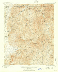
1911 Map of Cohutta Mountain
USGS Topo · Published 1955About this map
Hassler Mill and the surrounding timbered ridges of the southern Appalachians define this 1911 survey of the Georgia-Tennessee border. The Louisville and Nashville railroad runs along the western edge, serving small trackside communities like Tennga, Fairy, and Crandall. This rail connection was vital for the local economy, which relied on the complex drainage systems of the Conasauga River and Jack River.
Find a feature on this map
94 named features on this map. Tap any name to fly to it.
Don’t see what you’re looking for? This feature index may not catch every label — zoom into the map to look around manually.
Map Details
Editions of this 1911 Cohutta Mountain Map
2 editions found

Other maps of this area

1886 · Dalton
USGS Topo · 1:125,000

1886 · Cleveland
USGS Topo · 1:125,000

1888 · Ellijay
USGS Topo · 1:125,000

1892 · Cleveland
USGS Topo · 1:125,000

1892 · Ellijay
USGS Topo · 1:125,000

1892 · Dalton
USGS Topo · 1:125,000

1893 · Murphy
USGS Topo · 1:125,000

1895 · Cleveland
USGS Topo · 1:125,000

1897 · Dalton
USGS Topo · 1:125,000

1898 · Ellijay
USGS Topo · 1:125,000