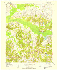
1954 Map of Coiltown
USGS Topo · Published 1955About this map
Stoney Point Mine and numerous active strip mines define this mid-century landscape in the Western Kentucky coalfield. The presence of the Louisville and Nashville and Illinois Central railroads facilitated the heavy extraction industrial economy, meeting at the Coiltown Junction. Settlement patterns are tied closely to the topography, with small communities like Coiltown and Rabbit Ridge appearing alongside historic landmarks such as Old Beulah Ch and Silent Run Ch. Along the bottomlands of Clear Creek and Pond Creek, the map details a transition from rural agriculture to intensive mining. Genealogists will find value in the specific locations of family-named features like Johnson Island Cem, Coffman Cem, and Hodge Cem, which dot the ridges and valleys between the industrial operations.
Find a feature on this map
31 named features on this map. Tap any name to fly to it.
Don’t see what you’re looking for? This feature index may not catch every label — zoom into the map to look around manually.
Map Details
Editions of this 1954 Coiltown Map
This is the sole edition of this map. No revisions or reprints were ever made.
Other maps of this area

1907 · Earlington
USGS Topo · 1:48,000

1908 · Princeton
USGS Topo · 1:62,500

1909 · Dawson Springs
USGS Topo · 1:48,000

1909 · Earlington
USGS Topo · 1:62,500

1909 · Providence
USGS Topo · 1:62,500

1910 · Princeton
USGS Topo · 1:62,500

1911 · Dawson Springs
USGS Topo · 1:62,500

1954 · Evansville
USGS Topo · 1:250,000
1954 · Nebo
USGS Topo · 1:24,000
1954 · Providence
USGS Topo · 1:24,000