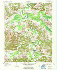
1954 Map of Dalton
USGS Topo · Published 1976About this map
Tradewater River winds in tight, serpentine oxbows through this landscape, marking the complex intersection of Hopkins, Caldwell, Webster, and Crittenden counties. The area's mid-century character is defined by a transition from traditional river valley agriculture to intensive resource extraction, visible in the cluster of Stoney Point Mines and a Strip Mine (Abandoned). The community of Dalton serves as a small rural hub, while Kirkwood Springs anchors the southern boundary.
Find a feature on this map
63 named features on this map. Tap any name to fly to it.
Don’t see what you’re looking for? This feature index may not catch every label — zoom into the map to look around manually.
Map Details
Editions of this 1954 Dalton Map
2 editions found
Other maps of this area

1907 · Earlington
USGS Topo · 1:48,000

1908 · Princeton
USGS Topo · 1:62,500

1909 · Dawson Springs
USGS Topo · 1:48,000

1909 · Earlington
USGS Topo · 1:62,500

1909 · Providence
USGS Topo · 1:62,500

1910 · Princeton
USGS Topo · 1:62,500

1911 · Dawson Springs
USGS Topo · 1:62,500

1954 · Evansville
USGS Topo · 1:250,000
1954 · Nebo
USGS Topo · 1:24,000
1954 · Shady Grove
USGS Topo · 1:24,000