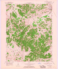
1954 Map of Slaughtersville
USGS Topo · Published 1967About this map
Slaughtersville sits at the northeastern corner of this Hopkins and Webster County landscape, a vital point on the Louisville and Nashville railroad line. The map reveals a rural economy transitioning in the mid-1950s, where small crossroad settlements like Veazey and landmarks such as Yarbro Hill are connected by a network of winding roads and numerous bridges crossing Deer Creek and its many tributaries.
Find a feature on this map
34 named features on this map. Tap any name to fly to it.
Don’t see what you’re looking for? This feature index may not catch every label — zoom into the map to look around manually.
Map Details
Editions of this 1954 Slaughtersville Map
2 editions found
Other maps of this area

1906 · Sebree
USGS Topo · 1:62,500

1907 · Earlington
USGS Topo · 1:48,000

1908 · Calhoun
USGS Topo · 1:62,500

1909 · Earlington
USGS Topo · 1:62,500

1909 · Madisonville
USGS Topo · 1:62,500

1949 · Sebree
USGS Topo · 1:24,000

1951 · Dixon
USGS Topo · 1:24,000

1951 · Sebree
USGS Topo · 1:24,000

1952 · Beech Grove
USGS Topo · 1:24,000

1952 · Hanson
USGS Topo · 1:24,000