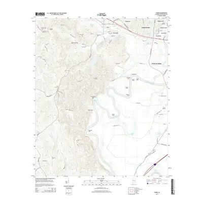
2014 Map of Coker
USGS Topo · Published 2014About this map
The Black Warrior River carves a deep, meandering path through this part of Tuscaloosa County, defining the landscape with significant features like Snows Bend, Clement Bend, and Marr Bend. To the west of the river, the terrain is characterized by numerous small drainages such as Sanders Mill Cr and Slaughter Cr, which separate the uplands where smaller settlements and family burial grounds are located. Genealogists will find a high concentration of small cemeteries, including Cornelius Chapel Number 1 Cem and Cornelius Chapel Number 2 Cem near Buhl, as well as the Old Liberty Cem and Spring Hill Cem. The northeastern corner transitions into the more suburban fringes of Northport and Tuscaloosa, featuring residential developments like Chapelwood and Cloverdale near the Bryce Hospital Lake. The map clearly illustrates the transition from the forested ridges of Forest Green to the managed waters of Warrior Lake and Lake Warner.
Find a feature on this map
102 named features on this map. Tap any name to fly to it.
Don’t see what you’re looking for? This feature index may not catch every label — zoom into the map to look around manually.
Map Details
Editions of this 2014 Coker Map
This is the sole edition of this map. No revisions or reprints were ever made.
Other maps of this area

1924 · Tuscaloosa
USGS Topo · 1:62,500

1926 · Samantha
USGS Topo · 1:48,000

1926 · Tuscaloosa
USGS Topo · 1:62,500

1928 · Samantha
USGS Topo · 1:62,500

1953 · Birmingham
USGS Topo · 1:250,000

1956 · Birmingham
USGS Topo · 1:250,000

1957 · Birmingham
USGS Topo · 1:250,000

1967 · Elrod
USGS Topo · 1:24,000
1969 · Fosters
USGS Topo · 1:24,000
1969 · Coker
USGS Topo · 1:24,000