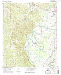
1969 Map of Coker
USGS Topo · Published 1978About this map
The Black Warrior River carves a dramatic serpentine path through this 1969 topographic study, defining the agricultural and industrial character of western Tuscaloosa County. The landscape is marked by deep alluvial bends, including Clement Bend, Snows Bend, and Robinson Bend, where the river's slow meander has created wide floodplains alongside prominent heights like Carson Bluff. Human settlement is anchored by the community of Coker and the northern outskirts of Tuscaloosa, where the Illinois Central Gulf RR and Columbus Road provide vital transit links. This era reveals a mix of rural tradition and institutional growth, evidenced by scattered country churches like Cornelius Chapel and Union Grove Ch alongside the expansive grounds of Bryce Hospital and modern infrastructure like Lake Warner. The inclusion of Gravel Pits and numerous gaging stations speaks to the region's managed natural resources and the industrial utility of the river valley.
Find a feature on this map
40 named features on this map. Tap any name to fly to it.
Don’t see what you’re looking for? This feature index may not catch every label — zoom into the map to look around manually.
Map Details
Editions of this 1969 Coker Map
3 editions found
Other maps of this area

1924 · Tuscaloosa
USGS Topo · 1:62,500

1926 · Samantha
USGS Topo · 1:48,000

1926 · Tuscaloosa
USGS Topo · 1:62,500

1928 · Samantha
USGS Topo · 1:62,500

1953 · Birmingham
USGS Topo · 1:250,000

1956 · Birmingham
USGS Topo · 1:250,000

1957 · Birmingham
USGS Topo · 1:250,000

1967 · Elrod
USGS Topo · 1:24,000
1969 · Fosters
USGS Topo · 1:24,000
1969 · Coker
USGS Topo · 1:24,000