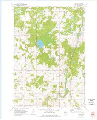
1973 Map of Colburn
USGS Topo · Published 1976About this map
The Yellow River winds through this rural section of Chippewa County, defining the drainage patterns and land divisions of the early 1970s. The settlement of Colburn serves as a local focal point near the center of the sheet, situated within a landscape primarily organized into the townships of Estella, Arthur, Colburn, Goetz, and Delmar. This area is characterized by a high density of water bodies and marshy terrain, notably around Pike Lake and the various tributaries like Hay Creek, Pike Creek, and Big Drywood Creek. For local historians and genealogists, the Walker-Jackson Cem located near the river provides a specific site of interest for family research. The economy of the era is evidenced by several Gravel Pit locations, while the presence of Coldwater Creek and Chap Creek further illustrate the well-watered geography of northern Wisconsin.
Find a feature on this map
15 named features on this map. Tap any name to fly to it.
Don’t see what you’re looking for? This feature index may not catch every label — zoom into the map to look around manually.
Map Details
Editions of this 1973 Colburn Map
This is the sole edition of this map. No revisions or reprints were ever made.
Other maps of this area

1951 · Cornell
USGS Topo · 1:62,500

1951 · Gilman
USGS Topo · 1:62,500

1952 · Cadott
USGS Topo · 1:62,500

1952 · Stanley
USGS Topo · 1:62,500

1953 · Eau Claire
USGS Topo · 1:250,000

1953 · Rice Lake
USGS Topo · 1:250,000

1958 · Eau Claire
USGS Topo · 1:250,000

1959 · Rice Lake
USGS Topo · 1:250,000

1964 · Eau Claire
USGS Topo · 1:250,000
1973 · Ruby
USGS Topo · 1:24,000