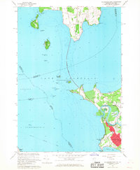
1966 Map of Colchester Point
USGS Topo · Published 1968About this map
Lake Champlain dominates this mid-1960s survey, illustrating the complex geography of the Vermont-New York border where South Hero Island meets the mainland. The landscape transitions from the residential growth of northern Burlington and Colchester to the more rural, aquatic character of the islands. Notable landmarks include the Lookout Tower on Stave Island and the Lighthouse at Colchester Reef, marking hazardous waters like Hogback Reef and Colchester Shoal.
Find a feature on this map
65 named features on this map. Tap any name to fly to it.
Don’t see what you’re looking for? This feature index may not catch every label — zoom into the map to look around manually.
Map Details
Editions of this 1966 Colchester Point Map
3 editions found
Other maps of this area

1894 · Plattsburg
USGS Topo · 1:62,500

1895 · Willsboro
USGS Topo · 1:62,500

1906 · Plattsburg
USGS Topo · 1:62,500

1906 · Burlington
USGS Topo · 1:62,500

1913 · Milton
USGS Topo · 1:48,000

1915 · Milton
USGS Topo · 1:62,500

1919 · Burlington
USGS Topo · 1:62,500

1939 · Plattsburg
USGS Topo · 1:62,500

1941 · Plattsburg
USGS Topo · 1:62,500

1941 · Willsboro
USGS Topo · 1:62,500