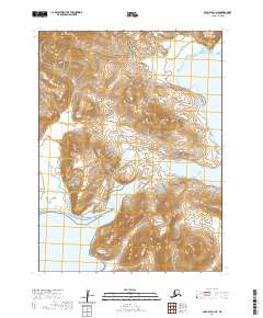
2020 Map of Cold Bay A-1 NE
USGS Topo · Published 2020About this map
Aleutian Range terrain dominates this coastal landscape along the southern edge of the Alaska Peninsula. The topography is defined by steep, high-elevation ridges that drop sharply into the North Pacific, creating a series of protected maritime features. Deep-water inlets like Captain Harbor and Volcano Bay provide natural shelter from the open sea, while smaller indentations such as Bear Bay and Kitchen Anchorage mark the rugged coastline. The map illustrates a wilderness shaped by tectonic and volcanic forces, where the lack of roads or established settlements emphasizes the isolation of the maritime environment. These coastal landmarks serve as critical points of reference for navigation in an area where the sea is the primary corridor for movement and transport.
Find a feature on this map
9 named features on this map. Tap any name to fly to it.
Don’t see what you’re looking for? This feature index may not catch every label — zoom into the map to look around manually.
Map Details
Editions of this 2020 Cold Bay A-1 NE Map
This is the sole edition of this map. No revisions or reprints were ever made.
Other maps of this area

1943 · Fort Randall
USGS Topo · 1:250,000

1949 · Fort Randall
USGS Topo · 1:250,000

1950 · Fort Randall
USGS Topo · 1:250,000

1953 · Port Moller
USGS Topo · 1:250,000

1963 · Port Moller A-6
USGS Topo · 1:63,360

1983 · Port Moller B-6
USGS Topo · 1:63,360
1983 · Cold Bay A-1
USGS Topo · 1:63,360
1983 · Cold Bay B-1
USGS Topo · 1:63,360

1988 · Port Moller
USGS Topo · 1:250,000
2020 · Cold Bay A-1 SW
USGS Topo · 1:25,000