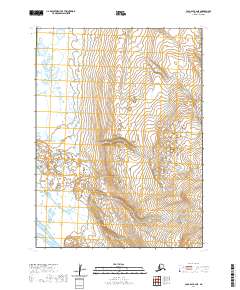
2020 Map of Cold Bay B-2 NE
USGS Topo · Published 2020About this map
Big Lake dominates the northwest corner of this coastal landscape within the Aleutians East Borough. The terrain is characterized by a dense network of small ponds and marshy depressions that sit between low-lying ridges, a pattern typical of the tundra environment found on the Alaska Peninsula. While the map is centered on natural topography rather than human settlement, it clearly delineates the t54s r86w and t54s r85w townships, providing a foundational grid for understanding land divisions in this part of the Aleutian Islands region. The concentration of wetlands surrounding the larger water body suggests a complex drainage system that feeds into the nearby Pacific coastal waters just off the map's edge.
Find a feature on this map
5 named features on this map. Tap any name to fly to it.
Don’t see what you’re looking for? This feature index may not catch every label — zoom into the map to look around manually.
Map Details
Editions of this 2020 Cold Bay B-2 NE Map
This is the sole edition of this map. No revisions or reprints were ever made.
Other maps of this area

1943 · Fort Randall
USGS Topo · 1:250,000
1944 · Cold Bay Sheet No. 2 of 25
USGS Topo · 1:25,000

1949 · Fort Randall
USGS Topo · 1:250,000

1950 · Fort Randall
USGS Topo · 1:250,000
1963 · Cold Bay C-2
USGS Topo · 1:63,360
1963 · Cold Bay C-1
USGS Topo · 1:63,360
1983 · Cold Bay B-1
USGS Topo · 1:63,360
1995 · Cold Bay B-2
USGS Topo · 1:63,360
2020 · Cold Bay B-1 NW
USGS Topo · 1:25,000
2020 · Cold Bay C-2 SE
USGS Topo · 1:25,000