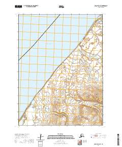
2020 Map of Cold Bay C-2 SE
USGS Topo · Published 2020About this map
The Alaska Peninsula meets the cold expanse of the Bering Sea in this coastal survey, where the terrestrial landscape is defined by its drainage systems and shoreline geometry. Water dominates the environment, as the Cathedral River and North Creek carve paths through the peninsula’s lowlands. Smaller tributaries like N Cr emphasize the intricate hydrology of this subarctic region. The map reflects a landscape where natural boundaries take precedence over human infrastructure, showing the intersection of the maritime and terrestrial worlds. These waterways were essential corridors for native movement and later exploration, providing a detailed look at the hydrology of the Aleutians East Borough before any significant industrial footprint. This 2020 record serves as a baseline for the shifting coastlines and river deltas of the high north.
Find a feature on this map
9 named features on this map. Tap any name to fly to it.
Don’t see what you’re looking for? This feature index may not catch every label — zoom into the map to look around manually.
Map Details
Editions of this 2020 Cold Bay C-2 SE Map
This is the sole edition of this map. No revisions or reprints were ever made.
Other maps of this area

1943 · Fort Randall
USGS Topo · 1:250,000
1944 · Cold Bay Sheet No. 2 of 25
USGS Topo · 1:25,000

1949 · Fort Randall
USGS Topo · 1:250,000

1950 · Fort Randall
USGS Topo · 1:250,000
1963 · Cold Bay C-2
USGS Topo · 1:63,360
1963 · Cold Bay C-1
USGS Topo · 1:63,360
1983 · Cold Bay B-1
USGS Topo · 1:63,360
1995 · Cold Bay B-2
USGS Topo · 1:63,360
2020 · Cold Bay B-2 NE
USGS Topo · 1:25,000
2020 · Cold Bay B-1 NW
USGS Topo · 1:25,000