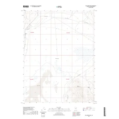
2018 Map of Cold Creek Ranch
USGS Topo · Published 2018About this map
Newark Valley dominates this High Desert landscape, where the seasonal waters of Newark Lake collect in a vast basin. The 2018 survey reveals a sparse settlement pattern centered around Cold Creek Ranch, a vital point of habitation near the drainage of Cold Cr. To the southeast, the terrain rises sharply into the Ruby Mountains, cut by the steep geography of Orchard Canyon. This map documents a quiet corner of White Pine County where transportation is defined by the winding path of White Pine Co Road 1, which skirts the edge of the mountains and traverses the flats. The survey captures the remote character of the Great Basin, illustrating the delicate relationship between water sources and ranching outposts in an arid environment.
Find a feature on this map
12 named features on this map. Tap any name to fly to it.
Don’t see what you’re looking for? This feature index may not catch every label — zoom into the map to look around manually.
Map Details
Editions of this 2018 Cold Creek Ranch Map
This is the sole edition of this map. No revisions or reprints were ever made.
Other maps of this area

1953 · Eureka
USGS Topo · 1:62,500

1956 · Ely
USGS Topo · 1:250,000

1957 · Buck Mountain
USGS Topo · 1:62,500

1957 · Diamond Springs
USGS Topo · 1:62,500

1957 · Cold Creek Ranch
USGS Topo · 1:62,500

1959 · Ely
USGS Topo · 1:250,000

1963 · Ely
USGS Topo · 1:250,000

1985 · Newark Lake
USGS Topo · 1:100,000
1990 · Buck Mountain East
USGS Topo · 1:24,000
1990 · Diamond Springs
USGS Topo · 1:24,000