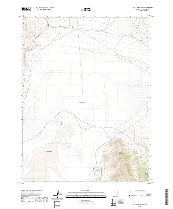
2021 Map of Cold Creek Ranch
USGS Topo · Published 2021About this map
Newark Valley dominates this high-desert landscape in central Nevada, where the valley floor meets the steep western rise of the Ruby Mountains. The map highlights a complex hydrological environment characterized by ephemeral waters and wetlands, including the seasonal Newark Lake and the eponymous Cold Creek in the northwest. This 2021 U.S. Geological Survey representation traces the rural infrastructure connecting this remote basin, primarily via White Pine Co Road 1 and Strawberry Rd. The contrast between the flat alkali sinks and the rugged descent of Orchard Canyon illustrates the classic Basin and Range topography of White Pine County. It is a sparsely populated area where the survey focuses on natural drainage patterns and the township and range grid system.
Find a feature on this map
11 named features on this map. Tap any name to fly to it.
Don’t see what you’re looking for? This feature index may not catch every label — zoom into the map to look around manually.
Map Details
Editions of this 2021 Cold Creek Ranch Map
This is the sole edition of this map. No revisions or reprints were ever made.
Other maps of this area

1953 · Eureka
USGS Topo · 1:62,500

1956 · Ely
USGS Topo · 1:250,000

1957 · Buck Mountain
USGS Topo · 1:62,500

1957 · Diamond Springs
USGS Topo · 1:62,500

1957 · Cold Creek Ranch
USGS Topo · 1:62,500

1959 · Ely
USGS Topo · 1:250,000

1963 · Ely
USGS Topo · 1:250,000

1985 · Newark Lake
USGS Topo · 1:100,000
1990 · Buck Mountain East
USGS Topo · 1:24,000
1990 · Diamond Springs
USGS Topo · 1:24,000