
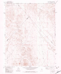
1980 Map of Cole Spring
USGS Topo · Published 1980About this map
Cole Spring serves as a lone water source in this high-desert basin where the borders of Nye, Mineral, and Esmeralda counties converge. The landscape is dominated by the massive ridge of the Cedar Mountains and the elevated terrain of the Royston Hills, which together frame the sweeping drainage of Cirac Valley. Evidence of the region's mineral interests is visible through scattered prospects and a quarry located in the northern reaches, connected only by a network of unimproved tracks and a Jeep Trail. To the southwest, the terrain descends into the Monte Cristo (Depression) Valley, illustrating the classic basin-and-range geography of Nevada. This survey documents the area just as modern photogrammetric mapping was refining the boundary lines between the three counties in the mid-1970s.
Find a feature on this map
12 named features on this map. Tap any name to fly to it.
Don’t see what you’re looking for? This feature index may not catch every label — zoom into the map to look around manually.
Map Details
Editions of this 1980 Cole Spring Map
2 editions found
Other maps of this area

1907 · Tonopah
USGS Topo · 1:250,000

1908 · Tonopah
USGS Topo · 1:250,000

1956 · Tonopah
USGS Topo · 1:250,000

1959 · Tonopah
USGS Topo · 1:250,000

1962 · Tonopah
USGS Topo · 1:250,000
1979 · Simon
USGS Topo · 1:24,000
1980 · Kibby Flat
USGS Topo · 1:24,000
1980 · Cloverdale Ranch
USGS Topo · 1:24,000
1980 · Outlaw Springs SE
USGS Topo · 1:24,000
1980 · Outlaw Springs NE
USGS Topo · 1:24,000