
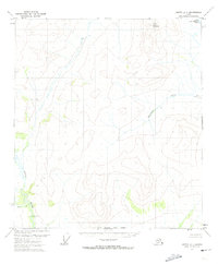
1972 Map of Coleen D-6
USGS Topo · Published 1974About this map
Shoulder Mountain dominates the central landscape of this 1970s interior Alaska survey, rising above the convergence of major glacial waterways. The topographical data, derived from 1972 aerial photography, reveals a rugged wilderness defined by the winding course of the Koness River as it joins the broader Sheenjek River valley. This confluence creates an intricate network of braided channels and wetlands, illustrating the dynamic hydrology of the Yukon-Koyukuk region before contemporary shifts in drainage patterns. The map also delineates the North Boundary Fairbanks Meridian, marking a critical point for land administration in an area otherwise devoid of permanent roads or settlements. This sheet is essential for understanding the pristine state of the eastern Brooks Range foothills during the early 1970s.
Find a feature on this map
4 named features on this map. Tap any name to fly to it.
Don’t see what you’re looking for? This feature index may not catch every label — zoom into the map to look around manually.
Map Details
Editions of this 1972 Coleen D-6 Map
This is the sole edition of this map. No revisions or reprints were ever made.
Other maps of this area

1951 · Coleen
USGS Topo · 1:250,000

1951 · Christian
USGS Topo · 1:250,000

1951 · Arctic
USGS Topo · 1:250,000

1951 · Table Mountain
USGS Topo · 1:250,000

1956 · Table Mountain
USGS Topo · 1:250,000

1956 · Coleen
USGS Topo · 1:250,000

1956 · Arctic
USGS Topo · 1:250,000

1956 · Christian
USGS Topo · 1:250,000

1964 · Table Mountain
USGS Topo · 1:250,000
1972 · Arctic A-1
USGS Topo · 1:63,360