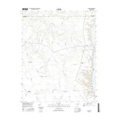
2016 Map of Colerain
USGS Topo · Published 2016About this map
The town of Colerain and the high bluffs overlooking the Chowan River define this portion of Bertie County near the border with Hertford County. The landscape is a network of water and wetlands, where the drainage of Chinkapin Swamp and Cypress Swamp flows toward the river's edge. Notable local clusters include Trap, Rosemead, and Wakelon, connected by a web of rural routes such as Buncomb Rd and Kitchen Spruill Rd. Along the riverfront, distinctive features like Goose Pond and Bull Pond Point mark the transition from the agricultural interior to the wide coastal waterway. Smaller settlements like Perrytown and Whites Crossroads appear near the southern boundary, surrounded by numerous named branches and swamps including Cricket Swamp and Barbeque Swamp. This survey documents a region where low-lying drainage basins dictate the placement of roads and family farms, preserving a detailed look at the rural geography of northeast North Carolina.
Find a feature on this map
66 named features on this map. Tap any name to fly to it.
Don’t see what you’re looking for? This feature index may not catch every label — zoom into the map to look around manually.
Map Details
Editions of this 2016 Colerain Map
This is the sole edition of this map. No revisions or reprints were ever made.
Other maps of this area

1904 · Edenton
USGS Topo · 1:62,500

1906 · Beckford
USGS Topo · 1:48,000

1907 · Beckford
USGS Topo · 1:62,500

1908 · Winton
USGS Topo · 1:62,500

1940 · Beckford
USGS Topo · 1:62,500

1942 · Edenton
USGS Topo · 1:62,500

1943 · Edenton
USGS Topo · 1:62,500

1953 · Norfolk
USGS Topo · 1:250,000
1981 · Windsor North
USGS Topo · 1:24,000

1982 · Powellsville
USGS Topo · 1:24,000